
The tides of change

Tuesday, June 15 2010
Unalaska, AK – This weekend, the National Oceanic and Atmospheric Administration completed the first part of its effort to redo tidal current maps for the Aleutian chain. It's been over fifty years since the maps have been updated.
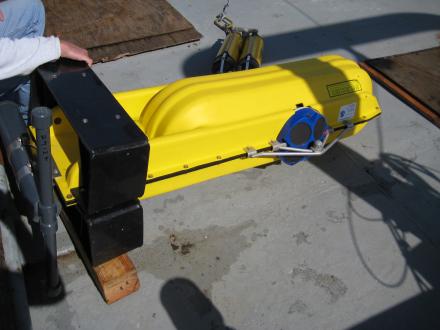
NOAA is using a total of 24 subsurface moorings to collect data in the area between Unimak Isand and Unalaska Island. Fifteen of those moorings were put in place on this trip. The moorings are shaped like torpedoes, and inside there's a meter that records information on the speed of the currents. The NOAA team attaches recycled railroad wheels to the moorings to keep them place.
In July, NOAA will collect many of these moorings and also put new ones out. The last of the moorings will be in place along the Aleutian Chain through September 15, and local mariners are advised to keep a lookout for them.
Steve Bassett, who is part of NOAA's tides and currents team, says that data collection should go smoothly, but there is a risk that the moorings could be moved accidentally.
"Our biggest concern is setting these things in areas that are heavily trawled," say Bassett. "Because if you have something sitting on the bottom and it's sitting in an area that's heavily trawled, you're going to scrape the mooring right up.
The NOAA team traveled the Aleutian chain on the fishing trawler Epic Explorer, led by Captain Dan Carney. Carney says that an update to the maps has been necessary for a long time.
"It's kind of overdue actually, particularly in Dutch Harbor and Akutan," says Carney. "But we're also looking forward to getting some updates for the areas right around Adak in the central Aleutian Islands there. Some of that data is just really nonexistent."
In addition to participating in research missions, Carney also fishes cod in the area. He stresses that the maps are critical navigational tools for fishermen like him.
The updated tidal current maps should be ready in two years.

